question

northcaptain avatar image
northcaptain asked

Cerbo GPS priorization

I ran through a strange GPS issue while installing the CERBO on my boat. I used the VE.CAN cable to interconnect with the NMEA 2000 network. On the NMEA2000 network there is a Furuno GP33 GPS which is a low power device and is the basic GPS of the boat when chart plotters and RADAR are off. When chart plotter (Furuno Navnet) are on, there is a 10 hz rapid update GPS coming on to support map with radar overlay and autopilot.

Upon connecting the VE.CAN i saw immediately the NMEA 2000 data coming but no position. Ok i found out the GP33 doesn't supply a 129025 PGN. No problem i picked up another GPS which is a USB BU353 and voila i got two GPS connected to the CERBO but only the BU353 give position.

Now in the VRM things are different. I have done several test and concluded that CERBO prioritize the information of the NMEA2000 GPS and not the USB. When both GPS are connected, no position is sent to VRM. If only the BU353 is connected, VRM receive position and geofence work. If only the NMEA2000 GPS is connected then no position in VRM.

I don't mind feeding the CERBO with the USB GPS but i'm losing all the integration with NMEA 2000 by disconnecting the VE.CAN cable. The GP33 is an old device (as is the BU353 by the way) and Furuno won't modify it to support 129025. I wonder if there is a way to "prioritize" the position information that is arriving on the CERBO when multiple GPS are connected ? If one position is blank in a GPS feed and the other is not blank, then use the non-blank.

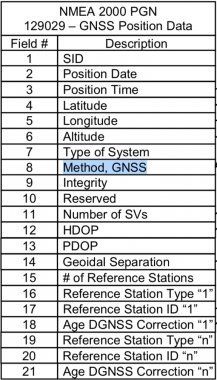
Or would it be possible for Cerbo to support the PGN 129029 which is another way of getting a position. The 129025 is a rapid update which is not required on the Cerbo, we are not displaying map and radar in real time here...

This would enable GPS failover scenario as well.


thanks for any advice on this situation.


cerbo gxVRMgps
2 |3000

Up to 8 attachments (including images) can be used with a maximum of 190.8 MiB each and 286.6 MiB total.

1 Answer
bathnm avatar image
bathnm answered ·

@Northcaptain Welcome to the world of NMEA200 and it's strange behaviours.

I have a Raymarine based setup with several GPS's. I have never had any issues with the VenusOS nots ending GPS position to VRM, or displaying GPS position. In fact my system regularly has 2 or 3 GPS to select from. I currently have a portion of my N2K network running and the Cerbo is not picking up the GPS sensor that is broadcast, just the USB one.

Have you read the VenusOS/Cerbo GX manual and section on GPS?

It does support PGN 129029, which is hight. The Lat and Long come from PGN129025.

Suspect what you are seeing is Furuno is not sending the PGNS from a device that has its device class and device function set to the N2K Standard. While anything can send a PGN of any message type, there are certain devices class and functions that should be trusted as being authoritative for sending certain data. In the VenusOS case it is looking or the position, heigh, speed and course PGN data to be coming from a device that has announced itself as class 60, navigation and function 145, Ownship Position (GNSS). If the messages are coming from a device that does not announce as being of the correct type the Cerbo/VenusOS will ignore the messages.

1 comment
2 |3000

Up to 8 attachments (including images) can be used with a maximum of 190.8 MiB each and 286.6 MiB total.

northcaptain avatar image northcaptain commented ·

Hello yes i've read all the Cerbo and VRM manual. The PGN 129029 is not height its it the complete GNDSS position data. The 129025 is a fast update version position of the 129029.

Since 2008 on my boat the GP33 has supplied lat and longitude to OpenCPN, Timezero PC, ICOM 802 HF, ICOM 602 radio, all kind of NMEA repeaters... the new Predictwind Data Hub. Name it everything read lat+long from a GP33 with only the 129029.

Enter Cerbo... they want the 129025 which "Position, rapid update" a subset of PGN 129029. This is not required for the CERBO, if you need to read a position on an NMEA2000 network you go with the PGN that's is the most common and the one which carries the most information. This is the reason the 129029 exist.

About Furuno they are one of the founding manufacturers on NMEA2000 and they are very strict on the correct support of N2K standard. I don't work for Furuno but i'm NMEA 2000 installer and i have seen all kind of integration problem with other brand, Furuno is quite clean. They support 129029 on the GP33 simply because in order to support 129025 you need to have a faster GPS rate at least 5hz or better 10hz and the GP33 in 2008 was not capable of that.

The GP33 is on the correct class because it send correctly the other PGN that are interpreted correctly - except position which is not sent by the GP33 in the 129025.

But CERBO doesn't need to have a position refreshed 5 times per second since it send the information to VRM at best every minute.

here is the content of PGN 129029. As you can see Field 4 and 5 are lat, long. There is even date and time + altitude in this PGN.


pgn129029.png


nmea-gps.png


I would like very much a Victron developer to chime in !


0 Likes 0 ·
pgn129029.png (55.7 KiB)
nmea-gps.png (71.3 KiB)