question

s1277 avatar image
s1277 asked

no solar forecast data anymore in vrm

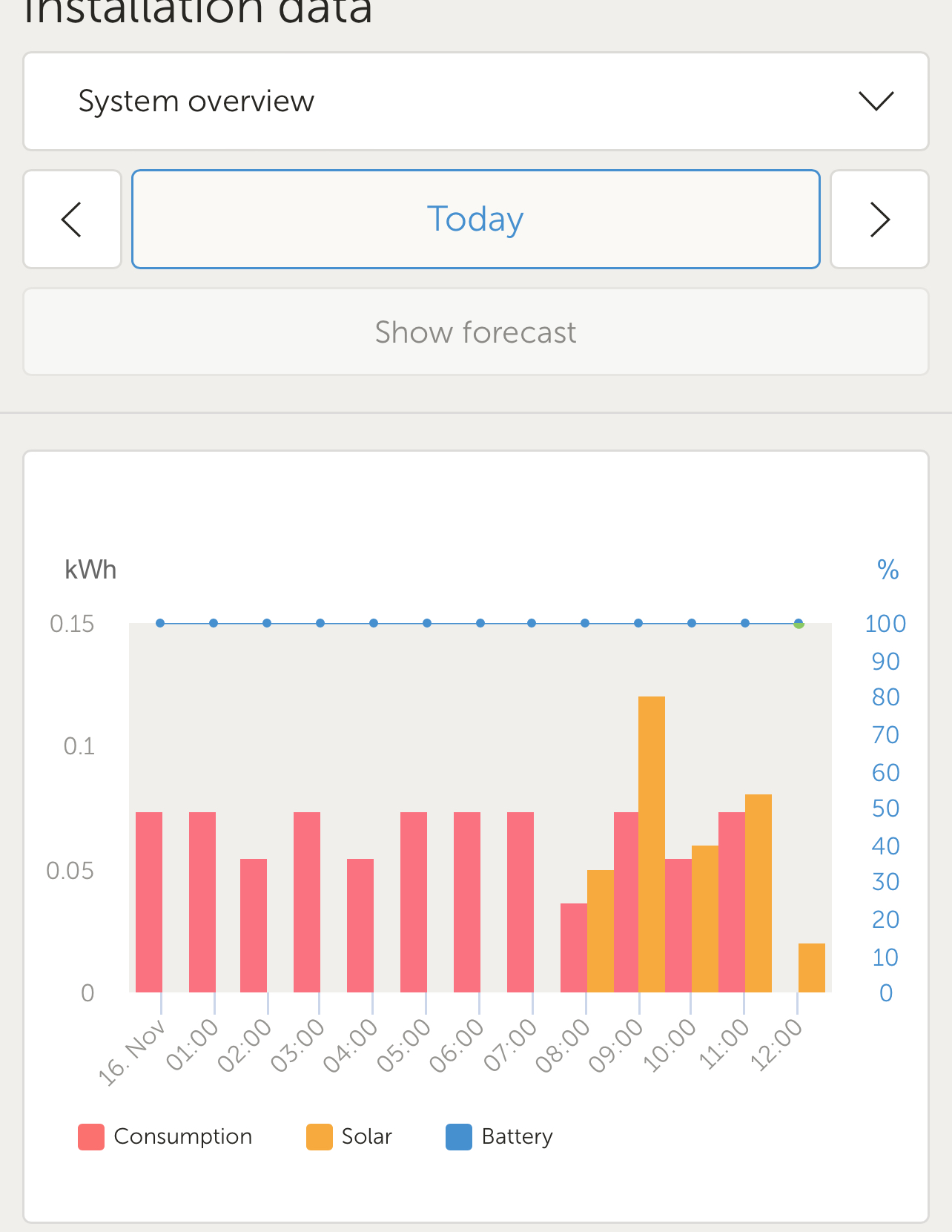
I no longer see solar forecast in vrm if I click it see below


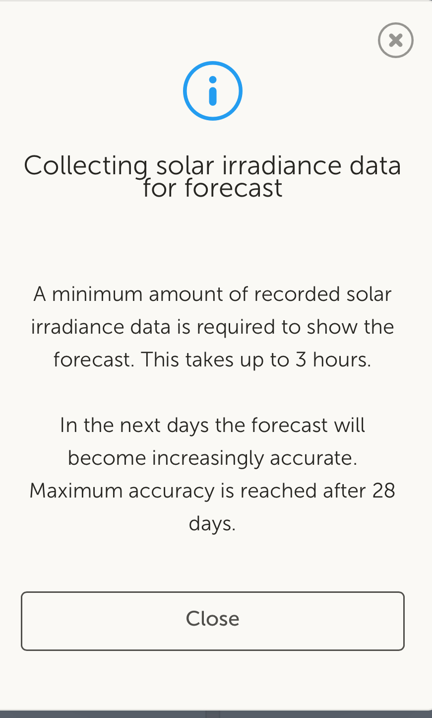
Collecting solar irradiance data for forecast


A minimum amount of recorded solar irradiance data is required to show the forecast. This takes up to 3 hours.

In the next days the forecast will become increasingly accurate. Maximum accuracy is reached after 28 days.

solar forecast
2 |3000

Up to 8 attachments (including images) can be used with a maximum of 190.8 MiB each and 286.6 MiB total.

4 Answers
Jason - UK avatar image
Jason - UK answered ·

@s1277 Have you clicked the highlighted button? Can you share a screenshot of your VRM display?

1700148859135.png


1700148859135.png (95.4 KiB)
1 comment
2 |3000

Up to 8 attachments (including images) can be used with a maximum of 190.8 MiB each and 286.6 MiB total.

s1277 avatar image s1277 commented ·

Yes if I click it the pop up comes up that’s it

img-4326.jpeg

0 Likes 0 ·
img-4326.jpeg (223.8 KiB)
img-4327.jpeg (330.5 KiB)
pb3 avatar image
pb3 answered ·

I have have the same issue, it used to show the forecast then just seemed to stop and now I just get the info message as shown above (s1277).

2 comments
2 |3000

Up to 8 attachments (including images) can be used with a maximum of 190.8 MiB each and 286.6 MiB total.

s1277 avatar image s1277 commented ·
seems to be a bug between location, geofence and gps and needs to be fixed. How do you report a bug for review?
0 Likes 0 ·
Hi @s1277,

I am not exactly sure yet that it is a bug?

It was a design choice that if the location changes, or the location is reset, that forecast should also be reset.

However in the cases where the location change is very small (like a moored boat with GPS), then the VRM team is already aware and looking at an improvement so that the location change needs to be significant.

1 Like 1 ·
kocki avatar image
kocki answered ·
1 comment
2 |3000

Up to 8 attachments (including images) can be used with a maximum of 190.8 MiB each and 286.6 MiB total.

s1277 avatar image s1277 commented ·
I did test the geo fence ....there was a bug where it did not allow you to reset geofence that was fixed so I reset it
0 Likes 0 ·
geekemeritus avatar image
geekemeritus answered ·

I have been 3 weeks in the New Mexico sun and it still reports "collecting data." I have no geofence set and the location is set by an externa USBl NMEA 2000 GPS. It worked for several months until about 4 weeks ago.

Seems like a bug to me.

3 comments
2 |3000

Up to 8 attachments (including images) can be used with a maximum of 190.8 MiB each and 286.6 MiB total.

s1277 avatar image s1277 commented ·
Mine still not working ether and am stationary
0 Likes 0 ·

Somewhere on the Bug / known limitation / intended feature continuum

It was originally different, but people were complaining that they were moving their sites and then getting inaccurate forecasts, so it was changed.

Each time the location changes at all, which happens if any GPS is connected even in a stationary vehicle, the algorithm is reset. The team is looking into making this less sensitive, but there is a case for both extremes so it might be a while before a compromise is found.

0 Likes 0 ·
s1277 avatar image s1277 Guy Stewart (Victron Community Manager) ♦♦ commented ·
@Guy Stewart (Victron Community Manager) Understand both For me it is stationary so a 1 mile radius option or something may help. An option you may want to consider it a multiple choice option like the way it is now. parked and by zip code or something and users can select the way they want it forecasted understanding limitations of each
0 Likes 0 ·

Related Resources

Additional resources still need to be added for this topic