question

brettj avatar image
brettj asked

Motorhome Dashboard

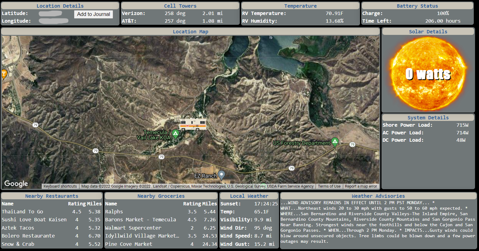
Thought I would share the motorhome dashboard I am working on. This displays on all TVs in the rig. This utilizes MQTT protocol with Victron and pulls long/lat data from a Pepwave. Thanks Victron for providing an API that lets me pull telemetry! - Brett


dashboard2.png

MQTT
dashboard2.png (1.4 MiB)
4 comments
2 |3000

Up to 8 attachments (including images) can be used with a maximum of 190.8 MiB each and 286.6 MiB total.

rzaenger avatar image rzaenger commented ·

Hi, this looks very interesting! Can you share more here? Specifically about the API query and subsequent output on the TV? Thank you @BrettJ.

0 Likes 0 ·
brettj avatar image brettj rzaenger commented ·

I'm utilizing a raspberry pi and all the code is written in node.js. I connect to a Cerbo GX using MQQT and pull the data on an interval. I originally had been sending the keepalive non-stop and just constantly pulling data. I didn't want to completely drain the battery in my Ruuvi temp sensor, so now I'm pulling on an interval. (I have it set to 60 seconds at the moment)

It would be nice if Victron provided a setting to only pull Ruuvi temp sensor data at a configured interval as to not deal with that limitation at the MQQT level, as I would rather pull constant telemetry. (It might be constantly pulling anyway? I haven't looked into the underlying implementation of how Victron is pulling that telemetry via bluetooth.)

In order to get Long/Lat, I'm pulling this from my Pepwave router, but this could just as easily be pulled from the cerbo with a GPS antenna attached to it. Pepwave has a configuration to send out GPS data an an interval, so I just open a UDP port and wait to receive data from it. (using NMEA, and GPGGA format)

API's I'm using are: Google Maps API, Yelp Fusion API (for restaurant/grocery data), and Visual Crossing's Weather API

The dashboard itself is just a webpage that updates automatically via jquery/ajax. I display the webpage in fullscreen making sure to use a TV friendly resolution (in this case 720p) and then there is an HDMI repeater in my rig that displays it on all tvs. We can also pull it up on anything with a web browser (iphone/ipad/computer)

My wife ultimately wants to Journal the locations we visit and add notes (best space numbers for KOA's, best boondocking locations, etc.) This will be my next effort to store this off to a database that we can refer back to.

0 Likes 0 ·
stager avatar image stager brettj commented ·

Data from d-bus no have timestamps, so the reliability of data should be the subject of special care on software.


Take a look at this, maybe something will seem interesting to you:

https://github.com/VladimirKalachikhin/Galadriel-map

0 Likes 0 ·
rzaenger avatar image rzaenger brettj commented ·
Thank you very much! @brettj
0 Likes 0 ·
0 Answers

Related Resources